Annular solar eclipse of 05/27/2226
| Day of week: | Saturday |
| Maximum duration of eclipse: | 03m55s |
| Maximum width of eclipse path: | 119 km |
| Saros cycle: | 141 |
| Coverage: | 96.7% |
| Magnitude: | 0.967 |
| Gamma: | -0.081 |
Wo kann man die Sonnenfinsternis vom 05/27/2226 sehen?

Die Sonnenfinsternis am 05/27/2226 kann man in 36 Ländern als partielle Sonnenfinsternis beobachten.
Der Finsternispfad verläuft durch 6 Länder. Nur in diesen Ländern ist sie als annular Sonnenfinsternis zu sehen.
In den folgenden Ländern ist die Sonnenfinsternis annular zu sehen
 United States
 Indonesia
 Australia
 Federated States of Micronesia
 Papua New Guinea
 Marshall Islands
In den folgenden Ländern ist die Sonnenfinsternis partiell zu sehen
 Fiji
Fiji
 United States
 United States Minor Outlying Islands
 Wallis and Futuna
 Tonga
Tonga
 Kiribati
 Samoa
Samoa
 Tokelau
 American Samoa
 Cook Islands
 French Polynesia
 Mexico
 Myanmar
 Indonesia
 Thailand
 Malaysia
 Laos
Laos
 Vietnam
 Cambodia
 Australia
 Brunei
 Taiwan
 Philippines
 Japan
Japan
 East Timor
 Palau
Palau
 Federated States of Micronesia
 Papua New Guinea
 Guam
Guam
 Northern Mariana Islands
 Solomon Islands
 New Caledonia
 Marshall Islands
 Vanuatu
 Nauru
Nauru
 Tuvalu
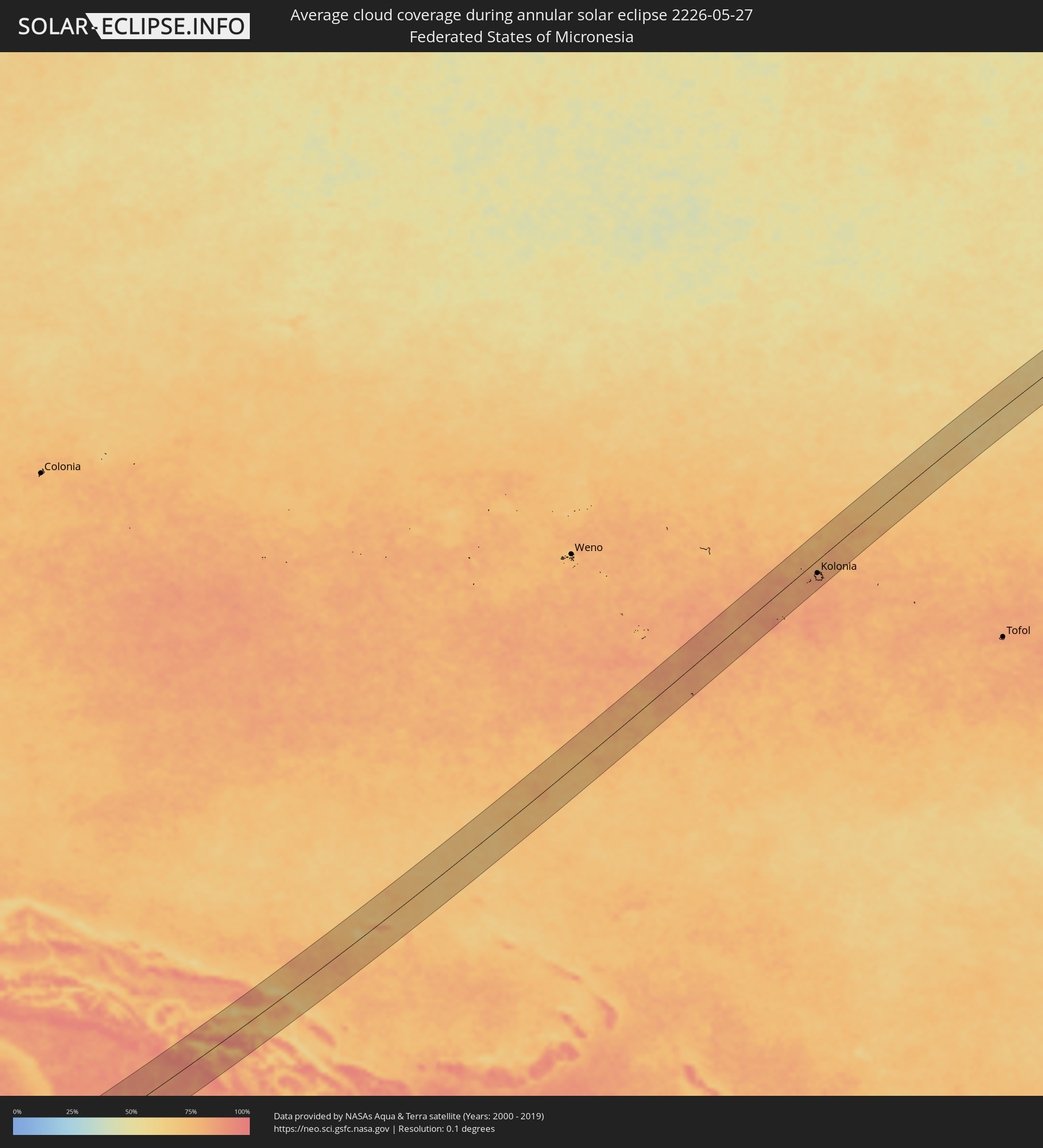
How will be the weather during the annular solar eclipse on 05/27/2226?
Where is the best place to see the annular solar eclipse of 05/27/2226?
The following maps show the average cloud coverage for the day of the annular solar eclipse.
With the help of these maps, it is possible to find the place along the eclipse path, which has the best
chance of a cloudless sky.
Nevertheless, you should consider local circumstances and inform about the weather of your chosen
observation site.
The data is provided by NASAs satellites
AQUA and TERRA.
The cloud maps are averaged over a period of 19 years (2000 - 2019).


Detailed country maps
 United States
 Indonesia
 Australia
 Federated States of Micronesia
 Papua New Guinea
 Marshall Islands
Cities inside the path of the eclipse
The following table shows all locations with a population of more than 5,000 inside the eclipse path. Cities which have more than 100,000 inhabitants are marked bold. A click at the locations opens a detailed map.
| City | Type | Eclipse duration | Local time of max. eclipse | Distance to central line | Ø Cloud coverage |
|
Mākaha, Hawaii
|
annular | - | 16:04:12 UTC-10:00 | 60 km | 70% |
|
Waianae, Hawaii
|
annular | - | 16:04:15 UTC-10:00 | 57 km | 61% |
|
Mā‘ili, Hawaii
|
annular | - | 16:04:16 UTC-10:00 | 55 km | 61% |
|
Nānākuli, Hawaii
|
annular | - | 16:04:19 UTC-10:00 | 53 km | 61% |
|
Makakilo, Hawaii
|
annular | - | 16:04:27 UTC-10:00 | 50 km | 69% |
|
Makakilo City, Hawaii
|
annular | - | 16:04:27 UTC-10:00 | 49 km | 50% |
|
Schofield Barracks, Hawaii
|
annular | - | 16:04:26 UTC-10:00 | 66 km | 76% |
|
‘Ewa Villages, Hawaii
|
annular | - | 16:04:32 UTC-10:00 | 49 km | 51% |
|
‘Ewa Gentry, Hawaii
|
annular | - | 16:04:33 UTC-10:00 | 49 km | 51% |
|
Village Park, Hawaii
|
annular | - | 16:04:32 UTC-10:00 | 56 km | 64% |
|
Royal Kunia, Hawaii
|
annular | - | 16:04:32 UTC-10:00 | 55 km | 64% |
|
Wahiawā, Hawaii
|
annular | - | 16:04:30 UTC-10:00 | 67 km | 72% |
|
Waipahu, Hawaii
|
annular | - | 16:04:34 UTC-10:00 | 55 km | 64% |
|
‘Ewa Beach, Hawaii
|
annular | - | 16:04:35 UTC-10:00 | 47 km | 51% |
|
Mililani Town, Hawaii
|
annular | - | 16:04:34 UTC-10:00 | 62 km | 72% |
|
Waipio, Hawaii
|
annular | - | 16:04:34 UTC-10:00 | 59 km | 64% |
|
Pearl City, Hawaii
|
annular | - | 16:04:37 UTC-10:00 | 57 km | 64% |
|
Hickam Field, Hawaii
|
annular | - | 16:04:40 UTC-10:00 | 51 km | 51% |
|
Waimalu, Hawaii
|
annular | - | 16:04:40 UTC-10:00 | 58 km | 69% |
|
‘Aiea, Hawaii
|
annular | - | 16:04:42 UTC-10:00 | 56 km | 69% |
|
Hālawa, Hawaii
|
annular | - | 16:04:43 UTC-10:00 | 56 km | 69% |
|
Hālawa Heights, Hawaii
|
annular | - | 16:04:44 UTC-10:00 | 56 km | 69% |
|
Honolulu, Hawaii
|
annular | - | 16:04:51 UTC-10:00 | 49 km | 54% |
|
‘Āhuimanu, Hawaii
|
annular | - | 16:04:50 UTC-10:00 | 64 km | 75% |
|
Kaneohe, Hawaii
|
annular | - | 16:04:55 UTC-10:00 | 60 km | 75% |
|
Marine Corps Base Hawaii - MCBH, Hawaii
|
annular | - | 16:04:59 UTC-10:00 | 66 km | 63% |
|
Kailua, Hawaii
|
annular | - | 16:05:01 UTC-10:00 | 62 km | 63% |
|
Waimanalo, Hawaii
|
annular | - | 16:05:04 UTC-10:00 | 56 km | 55% |
|
Napili-Honokowai, Hawaii
|
annular | - | 16:06:54 UTC-10:00 | 35 km | 46% |
|
Lahaina, Hawaii
|
annular | - | 16:06:56 UTC-10:00 | 24 km | 40% |
|
Wailuku, Hawaii
|
annular | - | 16:07:12 UTC-10:00 | 29 km | 60% |
|
Waihee-Waiehu, Hawaii
|
annular | - | 16:07:12 UTC-10:00 | 33 km | 60% |
|
Kahului, Hawaii
|
annular | - | 16:07:16 UTC-10:00 | 29 km | 60% |
|
Kīhei, Hawaii
|
annular | - | 16:07:21 UTC-10:00 | 16 km | 60% |
|
Pukalani, Hawaii
|
annular | - | 16:07:30 UTC-10:00 | 26 km | 74% |
|
Makawao, Hawaii
|
annular | - | 16:07:32 UTC-10:00 | 29 km | 64% |
|
Haiku-Pauwela, Hawaii
|
annular | - | 16:07:31 UTC-10:00 | 36 km | 64% |
|
Waikoloa Village, Hawaii
|
annular | - | 16:08:35 UTC-10:00 | 62 km | 70% |
|
Waimea, Hawaii
|
annular | - | 16:08:48 UTC-10:00 | 49 km | 63% |
|
Hilo, Hawaii
|
annular | - | 16:09:48 UTC-10:00 | 68 km | 81% |
|
Darwin, Northern Territory
|
annular | - | 08:16:13 UTC+09:30 | 21 km | 28% |
|
Palmerston, Northern Territory
|
annular | - | 08:16:16 UTC+09:30 | 11 km | 35% |
|
McMinns Lagoon, Northern Territory
|
annular | - | 08:16:16 UTC+09:30 | 2 km | 33% |
|
Kiunga, Western Province
|
annular | - | 08:57:56 UTC+10:00 | 7 km | 86% |
|
Lorengau, Manus
|
annular | - | 09:09:11 UTC+10:00 | 23 km | 70% |
|
Palikir - National Government Center, Pohnpei
|
annular | - | 10:42:01 UTC+11:00 | 28 km | 87% |
|
Kolonia Town, Pohnpei
|
annular | - | 10:42:12 UTC+11:00 | 28 km | 80% |
|
Kolonia, Pohnpei
|
annular | - | 10:42:12 UTC+11:00 | 28 km | 80% |
|
Enewetak, Enewetak Atoll
|
annular | - | 12:00:20 UTC+12:00 | 59 km | 63% |