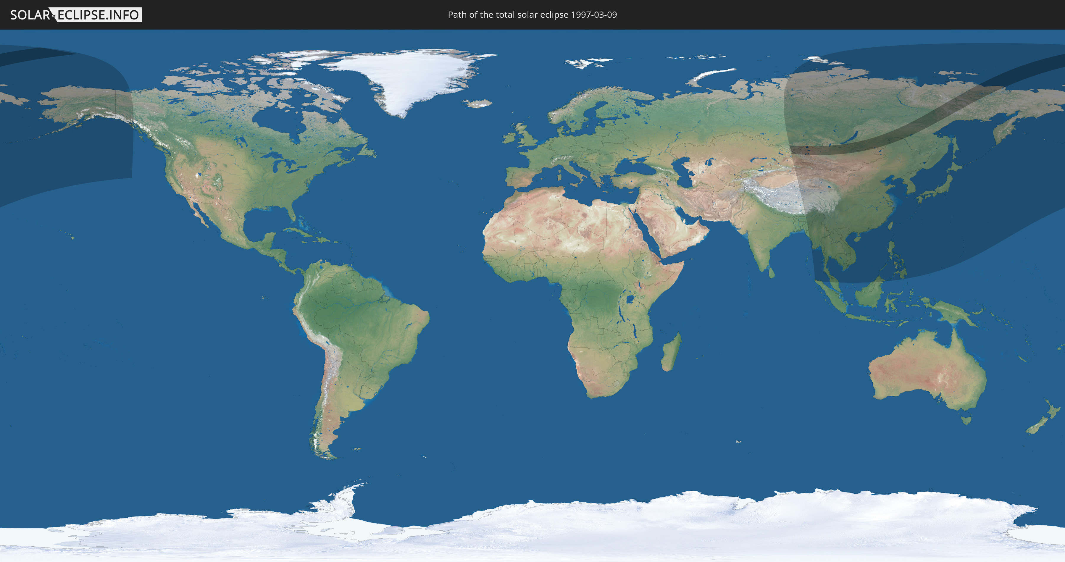
Total solar eclipse of 03/09/1997
Wo kann man die Sonnenfinsternis vom 03/09/1997 sehen?
Die Sonnenfinsternis am 03/09/1997 kann man in 26 Ländern als partielle Sonnenfinsternis beobachten.
Der Finsternispfad verläuft durch 3 Länder. Nur in diesen Ländern ist sie als total Sonnenfinsternis zu sehen.
In den folgenden Ländern ist die Sonnenfinsternis total zu sehen
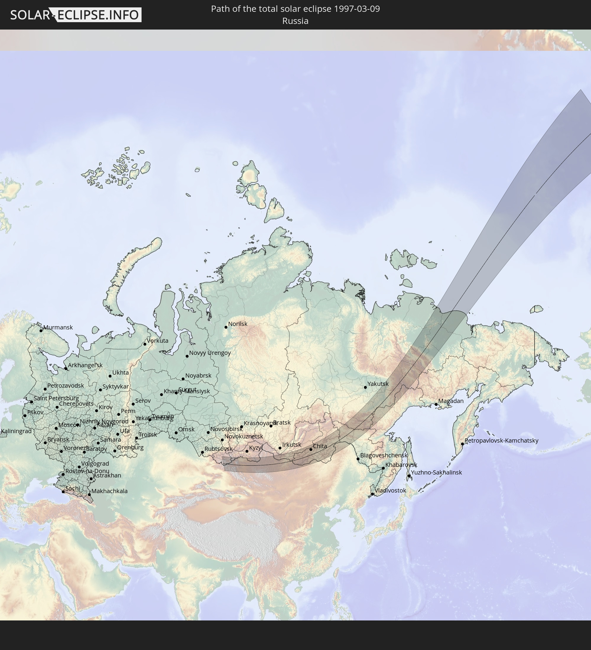 Russia
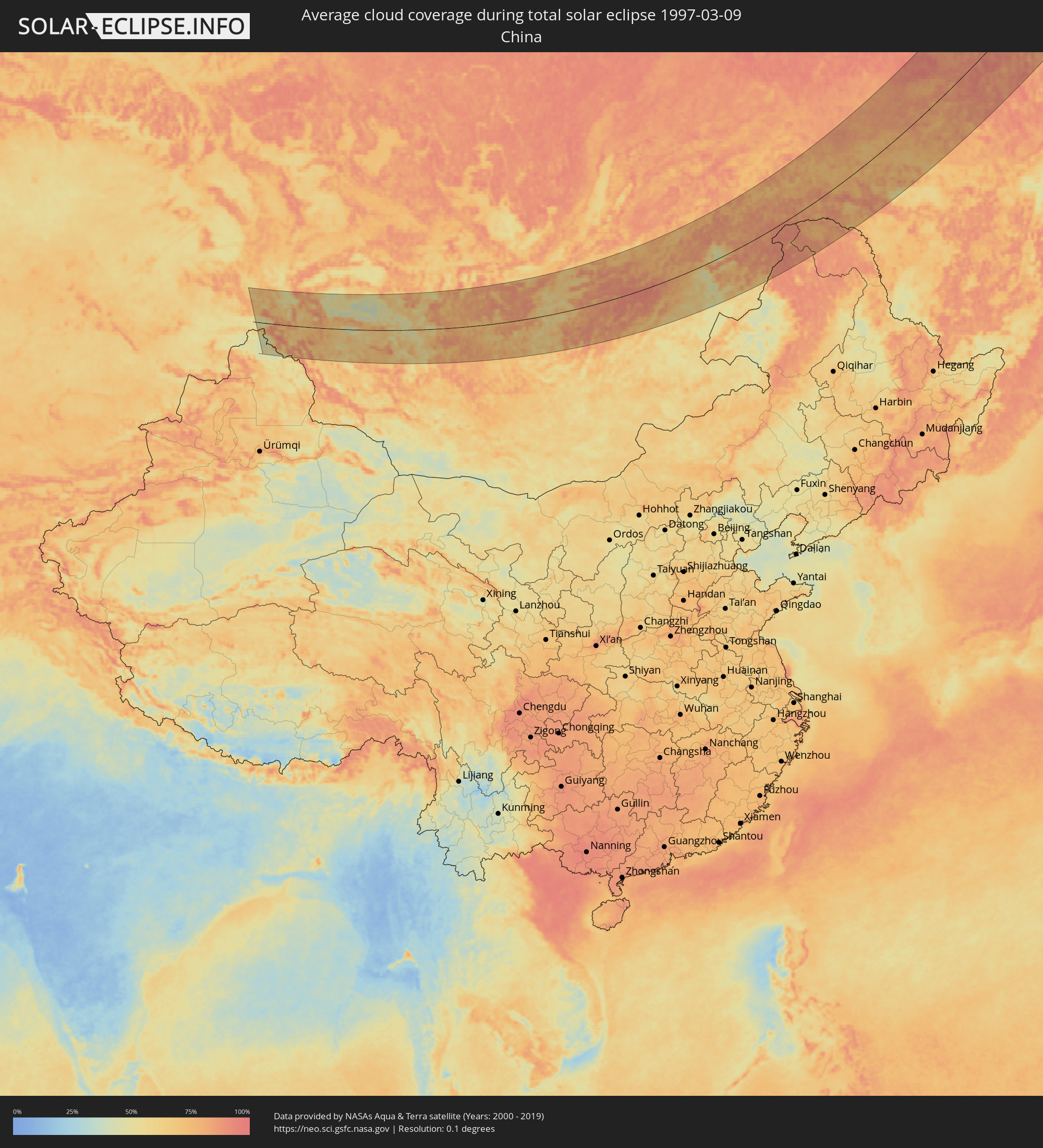
 China
China
 Mongolia
In den folgenden Ländern ist die Sonnenfinsternis partiell zu sehen


How will be the weather during the total solar eclipse on 03/09/1997?
Where is the best place to see the total solar eclipse of 03/09/1997?
The following maps show the average cloud coverage for the day of the total solar eclipse.
With the help of these maps, it is possible to find the place along the eclipse path, which has the best
chance of a cloudless sky.
Nevertheless, you should consider local circumstances and inform about the weather of your chosen
observation site.
The data is provided by NASAs satellites
AQUA and TERRA.
The cloud maps are averaged over a period of 19 years (2000 - 2019).


Detailed country maps
 Russia
 China
China
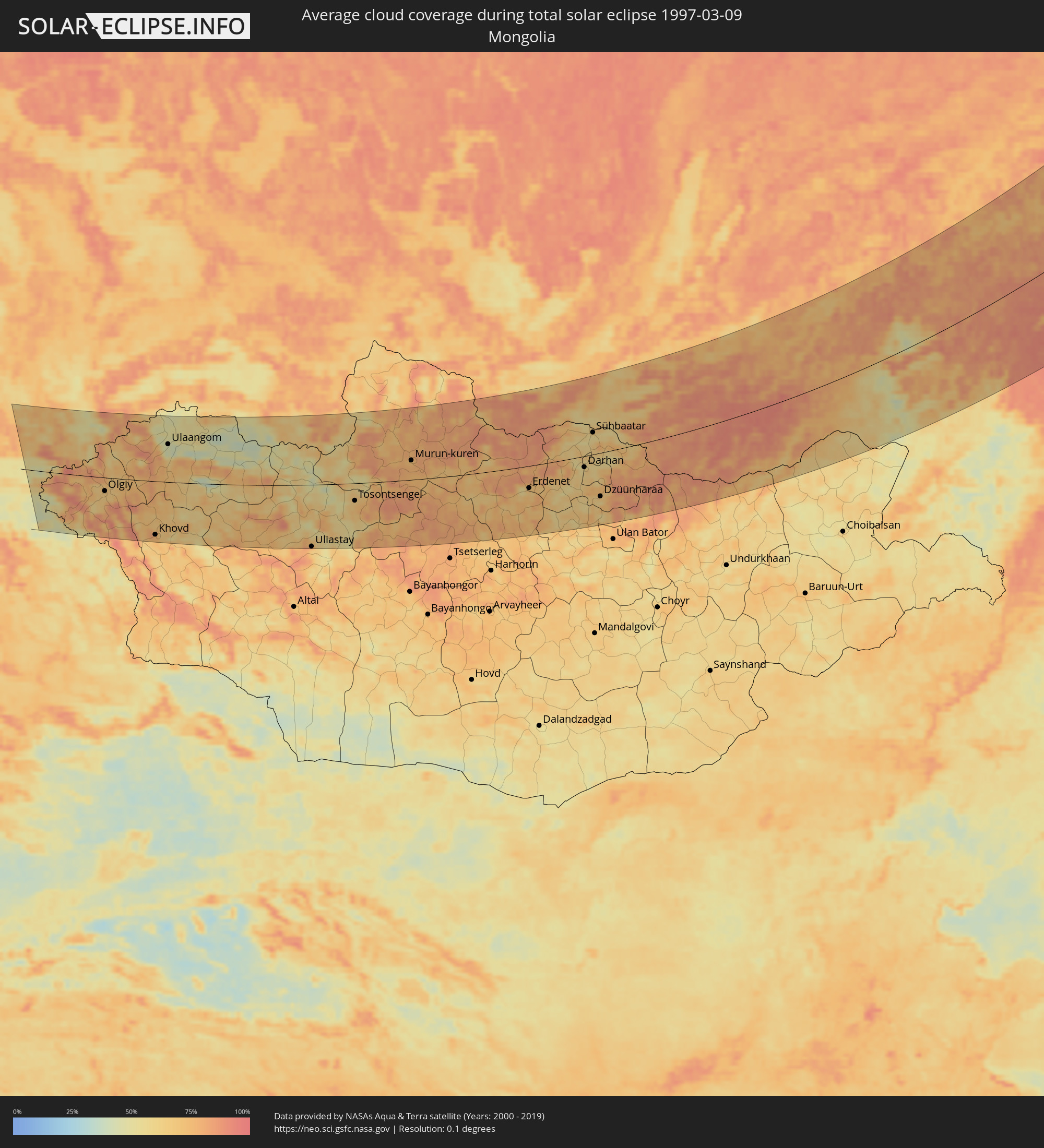 Mongolia
Cities inside the path of the eclipse
The following table shows all locations with a population of more than 5,000 inside the eclipse path. Cities which have more than 100,000 inhabitants are marked bold. A click at the locations opens a detailed map.
| City | Type | Eclipse duration | Local time of max. eclipse | Distance to central line | Ø Cloud coverage |
 Kosh-Agach, Altai Republic
|
total | - | 07:44:35 UTC+07:00 | 72 km | 68% |
 Ölgiy, Bayan-Ölgiy
|
total | - | 07:43:04 UTC+07:00 | 32 km | 66% |
|
Khovd, Hovd
|
total | - | 07:41:47 UTC+07:00 | 131 km | 76% |
|
Ulaangom, Uvs
|
total | - | 07:45:16 UTC+07:00 | 91 km | 44% |
|
Uliastay, Dzabkhan
|
total | - | 07:42:50 UTC+07:00 | 152 km | 70% |
|
Tosontsengel, Dzabkhan
|
total | - | 07:45:08 UTC+07:00 | 42 km | 65% |
|
Murun-kuren, Hövsgöl
|
total | - | 08:47:26 UTC+08:00 | 47 km | 76% |
|
Zakamensk, Respublika Buryatiya
|
total | - | 08:50:14 UTC+08:00 | 103 km | 85% |
|
Bulgan, Bulgan
|
total | - | 08:47:38 UTC+08:00 | 71 km | 71% |
|
Erdenet, Orhon
|
total | - | 08:48:18 UTC+08:00 | 53 km | 67% |
|
Petropavlovka, Respublika Buryatiya
|
total | - | 08:51:45 UTC+08:00 | 105 km | 74% |
|
Darhan, Darhan Uul
|
total | - | 08:50:08 UTC+08:00 | 26 km | 58% |
|
Sühbaatar, Selenge
|
total | - | 08:51:36 UTC+08:00 | 52 km | 56% |
|
Kyakhta, Respublika Buryatiya
|
total | - | 08:51:58 UTC+08:00 | 62 km | 66% |
|
Dzüünharaa, Selenge
|
total | - | 08:49:20 UTC+08:00 | 103 km | 66% |
|
Gusinoozyorsk, Respublika Buryatiya
|
total | - | 08:53:37 UTC+08:00 | 161 km | 69% |
|
Bichura, Respublika Buryatiya
|
total | - | 08:53:04 UTC+08:00 | 69 km | 71% |
|
Mukhorshibir’, Respublika Buryatiya
|
total | - | 08:54:01 UTC+08:00 | 115 km | 83% |
|
Krasnyy Chikoy, Transbaikal Territory
|
total | - | 09:53:25 UTC+09:00 | 23 km | 73% |
|
Petrovsk-Zabaykal’skiy, Transbaikal Territory
|
total | - | 09:55:04 UTC+09:00 | 120 km | 79% |
|
Bada, Transbaikal Territory
|
total | - | 09:55:56 UTC+09:00 | 112 km | 78% |
|
Kizhinga, Respublika Buryatiya
|
total | - | 08:56:46 UTC+08:00 | 159 km | 74% |
|
Khilok, Transbaikal Territory
|
total | - | 09:56:19 UTC+09:00 | 96 km | 82% |
|
Ulety, Transbaikal Territory
|
total | - | 09:57:44 UTC+09:00 | 49 km | 80% |
|
Domna, Transbaikal Territory
|
total | - | 09:59:10 UTC+09:00 | 89 km | 74% |
|
Chita, Transbaikal Territory
|
total | - | 09:59:39 UTC+09:00 | 93 km | 80% |
|
Dul’durga, Transbaikal Territory
|
total | - | 09:57:24 UTC+09:00 | 51 km | 78% |
|
Atamanovka, Transbaikal Territory
|
total | - | 09:59:35 UTC+09:00 | 80 km | 81% |
|
Novokruchininskiy, Transbaikal Territory
|
total | - | 09:59:26 UTC+09:00 | 60 km | 77% |
|
Darasun, Transbaikal Territory
|
total | - | 09:59:23 UTC+09:00 | 42 km | 73% |
|
Karymskoye, Transbaikal Territory
|
total | - | 09:59:36 UTC+09:00 | 28 km | 77% |
|
Aginskoye, Transbaikal Territory
|
total | - | 09:58:52 UTC+09:00 | 30 km | 74% |
|
Mogoytuy, Transbaikal Territory
|
total | - | 09:59:29 UTC+09:00 | 22 km | 69% |
|
Vershino-Darasunskiy, Transbaikal Territory
|
total | - | 10:01:48 UTC+09:00 | 71 km | 83% |
|
Olovyannaya, Transbaikal Territory
|
total | - | 09:59:27 UTC+09:00 | 74 km | 69% |
|
Pervomayskiy, Transbaikal Territory
|
total | - | 10:00:42 UTC+09:00 | 2 km | 65% |
|
Shilka, Transbaikal Territory
|
total | - | 10:01:20 UTC+09:00 | 4 km | 70% |
|
Borzya, Transbaikal Territory
|
total | - | 09:59:17 UTC+09:00 | 158 km | 56% |
|
Nerchinsk, Transbaikal Territory
|
total | - | 10:02:01 UTC+09:00 | 2 km | 64% |
|
Baley, Transbaikal Territory
|
total | - | 10:01:23 UTC+09:00 | 40 km | 67% |
|
Chernyshevsk, Transbaikal Territory
|
total | - | 10:03:17 UTC+09:00 | 42 km | 63% |
|
Kokuy, Transbaikal Territory
|
total | - | 10:03:12 UTC+09:00 | 6 km | 85% |
|
Sretensk, Transbaikal Territory
|
total | - | 10:03:24 UTC+09:00 | 6 km | 87% |
|
Mogocha, Transbaikal Territory
|
total | - | 10:07:37 UTC+09:00 | 71 km | 80% |
|
Yerofey Pavlovich, Amur
|
total | - | 10:09:57 UTC+09:00 | 14 km | 79% |
|
Skovorodino, Amur
|
total | - | 10:11:50 UTC+09:00 | 57 km | 84% |
|
Neryungri, Sakha
|
total | - | 10:16:32 UTC+09:00 | 153 km | 89% |
|
Tynda, Amur
|
total | - | 10:14:22 UTC+09:00 | 18 km | 78% |
|
Chul’man, Sakha
|
total | - | 10:17:02 UTC+09:00 | 157 km | 84% |
|
Magdagachi, Amur
|
total | - | 10:12:52 UTC+09:00 | 176 km | 72% |
|
Khandyga, Sakha
|
total | - | 10:34:04 UTC+09:00 | 162 km | 70% |
|
Ust-Nera, Sakha
|
total | - | 11:42:29 UTC+10:00 | 8 km | 70% |