Total solar eclipse of 05/28/2291
| Day of week: | Thursday |
| Maximum duration of eclipse: | 06m34s |
| Maximum width of eclipse path: | 249 km |
| Saros cycle: | 142 |
| Coverage: | 100% |
| Magnitude: | 1.0764 |
| Gamma: | 0.1153 |
Wo kann man die Sonnenfinsternis vom 05/28/2291 sehen?

Die Sonnenfinsternis am 05/28/2291 kann man in 40 Ländern als partielle Sonnenfinsternis beobachten.
Der Finsternispfad verläuft durch 9 Länder. Nur in diesen Ländern ist sie als total Sonnenfinsternis zu sehen.
In den folgenden Ländern ist die Sonnenfinsternis total zu sehen
 Mexico
 Guatemala
 El Salvador
 Honduras
 Belize
 Nicaragua
 Colombia
 Federated States of Micronesia
 Marshall Islands
In den folgenden Ländern ist die Sonnenfinsternis partiell zu sehen
 Fiji
Fiji
 United States
 United States Minor Outlying Islands
 Wallis and Futuna
 Tonga
Tonga
 Kiribati
 Samoa
Samoa
 Tokelau
 American Samoa
 Cook Islands
 Canada
 Mexico
 Guatemala
 Ecuador
 El Salvador
 Honduras
 Belize
 Nicaragua
 Costa Rica
 Cuba
Cuba
 Panama
 Colombia
 Cayman Islands
 The Bahamas
 Jamaica
 Haiti
Haiti
 Turks and Caicos Islands
 Dominican Republic
 Bermuda
 Japan
Japan
 Federated States of Micronesia
 Papua New Guinea
 Guam
Guam
 Northern Mariana Islands
 Solomon Islands
 New Caledonia
 Marshall Islands
 Vanuatu
 Nauru
Nauru
 Tuvalu
How will be the weather during the total solar eclipse on 05/28/2291?
Where is the best place to see the total solar eclipse of 05/28/2291?
The following maps show the average cloud coverage for the day of the total solar eclipse.
With the help of these maps, it is possible to find the place along the eclipse path, which has the best
chance of a cloudless sky.
Nevertheless, you should consider local circumstances and inform about the weather of your chosen
observation site.
The data is provided by NASAs satellites
AQUA and TERRA.
The cloud maps are averaged over a period of 19 years (2000 - 2019).


Detailed country maps
 Mexico
 Guatemala
 El Salvador
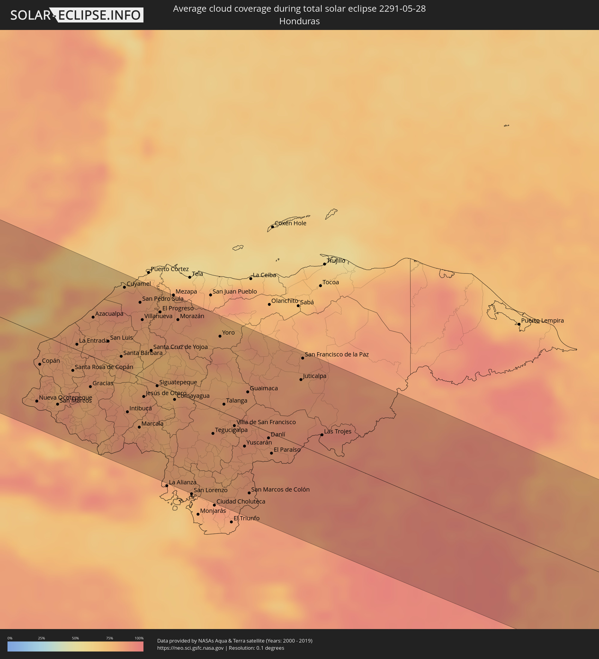 Honduras
 Belize
 Nicaragua
 Colombia
 Federated States of Micronesia
 Marshall Islands
Cities inside the path of the eclipse
The following table shows all locations with a population of more than 5,000 inside the eclipse path. Cities which have more than 100,000 inhabitants are marked bold. A click at the locations opens a detailed map.
| City | Type | Eclipse duration | Local time of max. eclipse | Distance to central line | Ø Cloud coverage |
|
La Paz, Baja California Sur
|
total | - | 15:49:19 UTC-07:00 | 77 km | 9% |
|
Puerto Vallarta, Jalisco
|
total | - | 16:58:17 UTC-06:00 | 101 km | 42% |
|
Tepic, Nayarit
|
total | - | 15:57:50 UTC-07:00 | 4 km | 29% |
|
Guadalajara, Jalisco
|
total | - | 17:00:00 UTC-06:00 | 25 km | 24% |
|
Tonalá, Jalisco
|
total | - | 17:00:11 UTC-06:00 | 23 km | 26% |
|
Uruapan, Michoacán
|
total | - | 17:02:15 UTC-06:00 | 101 km | 50% |
|
León de los Aldama, Guanajuato
|
total | - | 17:01:05 UTC-06:00 | 91 km | 27% |
|
Irapuato, Guanajuato
|
total | - | 17:01:44 UTC-06:00 | 57 km | 28% |
|
Salamanca, Guanajuato
|
total | - | 17:01:58 UTC-06:00 | 53 km | 24% |
|
Morelia, Michoacán
|
total | - | 17:02:43 UTC-06:00 | 36 km | 50% |
|
Celaya, Guanajuato
|
total | - | 17:02:18 UTC-06:00 | 63 km | 28% |
|
Santiago de Querétaro, Querétaro
|
total | - | 17:02:35 UTC-06:00 | 87 km | 29% |
|
Toluca, México
|
total | - | 17:04:14 UTC-06:00 | 17 km | 54% |
|
Ciudad López Mateos, México
|
total | - | 17:04:16 UTC-06:00 | 30 km | 41% |
|
Cuernavaca, Morelos
|
total | - | 17:04:50 UTC-06:00 | 36 km | 43% |
|
Tlalpan, Mexico City
|
total | - | 17:04:34 UTC-06:00 | 4 km | 46% |
|
Mexico City, Mexico City
|
total | - | 17:04:29 UTC-06:00 | 19 km | 36% |
|
Ecatepec, México
|
total | - | 17:04:22 UTC-06:00 | 41 km | 34% |
|
Santa María Chimalhuacán, México
|
total | - | 17:04:37 UTC-06:00 | 26 km | 36% |
|
Cuautla Morelos, Morelos
|
total | - | 17:05:08 UTC-06:00 | 37 km | 37% |
|
San Miguel Xico Viejo, México
|
total | - | 17:04:45 UTC-06:00 | 11 km | 43% |
|
Pachuca de Soto, Hidalgo
|
total | - | 17:04:11 UTC-06:00 | 106 km | 39% |
|
Puebla, Puebla
|
total | - | 17:05:26 UTC-06:00 | 17 km | 40% |
|
Tehuacán, Puebla
|
total | - | 17:06:25 UTC-06:00 | 9 km | 41% |
|
Córdoba, Veracruz
|
total | - | 17:06:22 UTC-06:00 | 54 km | 65% |
|
Minatitlan, Veracruz
|
total | - | 17:08:22 UTC-06:00 | 62 km | 68% |
|
Coatzacoalcos, Veracruz
|
total | - | 17:08:19 UTC-06:00 | 81 km | 66% |
|
Tuxtla, Chiapas
|
total | - | 17:09:59 UTC-06:00 | 4 km | 72% |
|
San Cristóbal de las Casas, Chiapas
|
total | - | 17:10:12 UTC-06:00 | 13 km | 77% |
|
Jacaltenango, Huehuetenango
|
total | - | 17:11:19 UTC-06:00 | 58 km | 80% |
|
Cabricán, Quetzaltenango
|
total | - | 17:11:44 UTC-06:00 | 107 km | 79% |
|
San Mateo Ixtatán, Huehuetenango
|
total | - | 17:11:18 UTC-06:00 | 30 km | 80% |
|
Huehuetenango, Huehuetenango
|
total | - | 17:11:39 UTC-06:00 | 82 km | 69% |
|
Barillas, Huehuetenango
|
total | - | 17:11:22 UTC-06:00 | 26 km | 76% |
|
Nebaj, Quiché
|
total | - | 17:11:43 UTC-06:00 | 60 km | 79% |
|
Chichicastenango, Quiché
|
total | - | 17:12:02 UTC-06:00 | 107 km | 83% |
|
Joyabaj, Quiché
|
total | - | 17:12:06 UTC-06:00 | 87 km | 69% |
|
San Cristóbal Verapaz, Alta Verapaz
|
total | - | 17:11:55 UTC-06:00 | 36 km | 81% |
|
Chinautla, Guatemala
|
total | - | 17:12:24 UTC-06:00 | 104 km | 76% |
|
Cobán, Alta Verapaz
|
total | - | 17:11:55 UTC-06:00 | 20 km | 82% |
|
Palencia, Guatemala
|
total | - | 17:12:28 UTC-06:00 | 102 km | 81% |
|
Salamá, Baja Verapaz
|
total | - | 17:12:11 UTC-06:00 | 56 km | 75% |
|
Chisec, Alta Verapaz
|
total | - | 17:11:43 UTC-06:00 | 19 km | 84% |
|
Sanarate, El Progreso
|
total | - | 17:12:26 UTC-06:00 | 82 km | 77% |
|
Jalapa, Jalapa
|
total | - | 17:12:36 UTC-06:00 | 90 km | 86% |
|
San Agustín Acasaguastlán, El Progreso
|
total | - | 17:12:24 UTC-06:00 | 56 km | 78% |
|
Monjas, Jalapa
|
total | - | 17:12:44 UTC-06:00 | 98 km | 81% |
|
Santa Catarina Mita, Jutiapa
|
total | - | 17:12:48 UTC-06:00 | 98 km | 78% |
|
San Luis Jilotepeque, Jalapa
|
total | - | 17:12:40 UTC-06:00 | 77 km | 80% |
|
Panzós, Alta Verapaz
|
total | - | 17:12:11 UTC-06:00 | 2 km | 78% |
|
Chiquimula, Chiquimula
|
total | - | 17:12:37 UTC-06:00 | 54 km | 80% |
|
Zacapa, Zacapa
|
total | - | 17:12:31 UTC-06:00 | 36 km | 75% |
|
Metapán, Santa Ana
|
total | - | 17:12:57 UTC-06:00 | 98 km | 74% |
|
Gualán, Zacapa
|
total | - | 17:12:28 UTC-06:00 | 13 km | 75% |
|
Esquipulas, Chiquimula
|
total | - | 17:12:50 UTC-06:00 | 70 km | 87% |
|
El Estor, Izabal
|
total | - | 17:12:11 UTC-06:00 | 29 km | 67% |
|
Nueva Ocotepeque, Ocotepeque
|
total | - | 17:12:58 UTC-06:00 | 76 km | 85% |
|
Morales, Izabal
|
total | - | 17:12:22 UTC-06:00 | 47 km | 76% |
|
Santa Rosa de Copán, Copán
|
total | - | 17:12:51 UTC-06:00 | 25 km | 81% |
|
Lívingston, Izabal
|
total | - | 17:12:09 UTC-06:00 | 85 km | 75% |
|
La Entrada, Copán
|
total | - | 17:12:41 UTC-06:00 | 6 km | 83% |
|
Puerto Barrios, Izabal
|
total | - | 17:12:15 UTC-06:00 | 81 km | 81% |
|
Gracias, Lempira
|
total | - | 17:13:01 UTC-06:00 | 35 km | 80% |
|
Ciudad Barrios, San Miguel
|
total | - | 17:13:37 UTC-06:00 | 106 km | 87% |
|
Santa Bárbara, Santa Bárbara
|
total | - | 17:12:53 UTC-06:00 | 14 km | 81% |
|
Intibucá, Intibucá
|
total | - | 17:13:18 UTC-06:00 | 45 km | 87% |
|
Cofradía, Cortés
|
total | - | 17:12:35 UTC-06:00 | 67 km | 81% |
|
San Francisco, Morazán
|
total | - | 17:13:42 UTC-06:00 | 105 km | 82% |
|
Marcala, La Paz
|
total | - | 17:13:26 UTC-06:00 | 56 km | 83% |
|
San Pedro Sula, Cortés
|
total | - | 17:12:33 UTC-06:00 | 83 km | 86% |
|
Villanueva, Cortés
|
total | - | 17:12:41 UTC-06:00 | 64 km | 81% |
|
Pimienta Vieja, Cortés
|
total | - | 17:12:45 UTC-06:00 | 57 km | 78% |
|
Santa Cruz de Yojoa, Cortés
|
total | - | 17:12:55 UTC-06:00 | 35 km | 74% |
|
Santa Rosa de Lima, La Unión
|
total | - | 17:13:47 UTC-06:00 | 104 km | 81% |
|
Agua Blanca Sur, Yoro
|
total | - | 17:12:45 UTC-06:00 | 63 km | 79% |
|
Siguatepeque, Comayagua
|
total | - | 17:13:11 UTC-06:00 | 2 km | 79% |
|
El Progreso, Yoro
|
total | - | 17:12:40 UTC-06:00 | 81 km | 84% |
|
El Negrito, Yoro
|
total | - | 17:12:45 UTC-06:00 | 77 km | 85% |
|
La Paz, La Paz
|
total | - | 17:13:24 UTC-06:00 | 24 km | 77% |
|
Comayagua, Comayagua
|
total | - | 17:13:20 UTC-06:00 | 9 km | 79% |
|
Morazán, Yoro
|
total | - | 17:12:46 UTC-06:00 | 81 km | 85% |
|
Nacaome, Valle
|
total | - | 17:13:56 UTC-06:00 | 96 km | 77% |
|
Santa Rita, Yoro
|
total | - | 17:12:56 UTC-06:00 | 79 km | 79% |
|
Tegucigalpa, Francisco Morazán
|
total | - | 17:13:39 UTC-06:00 | 28 km | 81% |
|
Yoro, Yoro
|
total | - | 17:12:59 UTC-06:00 | 83 km | 87% |
|
Talanga, Francisco Morazán
|
total | - | 17:13:28 UTC-06:00 | 9 km | 81% |
|
Guaimaca, Francisco Morazán
|
total | - | 17:13:26 UTC-06:00 | 34 km | 82% |
|
San Marcos de Colón, Choluteca
|
total | - | 17:14:07 UTC-06:00 | 78 km | 84% |
|
Danlí, El Paraíso
|
total | - | 17:13:48 UTC-06:00 | 7 km | 83% |
|
Somoto, Madriz
|
total | - | 17:14:08 UTC-06:00 | 63 km | 84% |
|
El Paraíso, El Paraíso
|
total | - | 17:13:54 UTC-06:00 | 23 km | 85% |
|
Ocotal, Nueva Segovia
|
total | - | 17:14:04 UTC-06:00 | 43 km | 85% |
|
Condega, Estelí
|
total | - | 17:14:14 UTC-06:00 | 68 km | 89% |
|
Estelí, Estelí
|
total | - | 17:14:24 UTC-06:00 | 94 km | 86% |
|
Juticalpa, Olancho
|
total | - | 17:13:27 UTC-06:00 | 73 km | 83% |
|
Jalapa, Nueva Segovia
|
total | - | 17:13:56 UTC-06:00 | 1 km | 87% |
|
San Rafael del Norte, Jinotega
|
total | - | 17:14:22 UTC-06:00 | 71 km | 86% |
|
Quilalí, Nueva Segovia
|
total | - | 17:14:10 UTC-06:00 | 31 km | 89% |
|
Jinotega, Jinotega
|
total | - | 17:14:27 UTC-06:00 | 78 km | 87% |
|
Matagalpa, Matagalpa
|
total | - | 17:14:34 UTC-06:00 | 92 km | 88% |
|
Wiwilí, Nueva Segovia
|
total | - | 17:14:10 UTC-06:00 | 16 km | 90% |
|
Matiguás, Matagalpa
|
total | - | 17:14:41 UTC-06:00 | 82 km | 93% |
|
Waslala, Atlántico Norte (RAAN)
|
total | - | 17:14:28 UTC-06:00 | 38 km | 91% |
|
Río Blanco, Matagalpa
|
total | - | 17:14:40 UTC-06:00 | 62 km | 91% |
|
Bocana de Paiwas, Atlántico Sur
|
total | - | 17:14:46 UTC-06:00 | 73 km | 93% |
|
Siuna, Atlántico Norte (RAAN)
|
total | - | 17:14:14 UTC-06:00 | 39 km | 91% |
|
Bonanza, Atlántico Norte (RAAN)
|
total | - | 17:14:05 UTC-06:00 | 77 km | 91% |
|
Rama, Atlántico Sur
|
total | - | 17:15:12 UTC-06:00 | 99 km | 92% |
|
Bluefields, Atlántico Sur
|
total | - | 17:15:19 UTC-06:00 | 95 km | 87% |
|
Laguna de Perlas, Atlántico Sur
|
total | - | 17:15:09 UTC-06:00 | 57 km | 88% |
|
Corn Island, Atlántico Sur
|
total | - | 17:15:17 UTC-06:00 | 48 km | 83% |
|
San Andrés, Archipiélago de San Andrés, Providencia y Santa Catalina
|
total | - | 18:15:06 UTC-05:00 | 51 km | 84% |
|
San Bernardo del Viento, Córdoba
|
total | - | 18:16:13 UTC-05:00 | 43 km | 89% |
|
Cartagena, Bolívar
|
total | - | 18:15:40 UTC-05:00 | 83 km | 88% |
|
Turbaná, Bolívar
|
total | - | 18:15:43 UTC-05:00 | 73 km | 89% |
|
Turbaco, Bolívar
|
total | - | 18:15:41 UTC-05:00 | 80 km | 89% |
|
Santa Rosa, Bolívar
|
total | - | 18:15:38 UTC-05:00 | 94 km | 91% |
|
Ujae, Ujae Atoll
|
total | - | 07:56:32 UTC+12:00 | 39 km | 66% |
|
Wotho, Wotho Atoll
|
total | - | 07:57:33 UTC+12:00 | 73 km | 69% |
|
Lae, Lae Atoll
|
total | - | 07:56:42 UTC+12:00 | 64 km | 65% |
|
Utrik, Utrik Atoll
|
total | - | 08:00:03 UTC+12:00 | 3 km | 68% |
|
Ailuk, Ailuk Atoll
|
total | - | 07:59:17 UTC+12:00 | 110 km | 65% |