Total solar eclipse of 10/17/2153
| Day of week: | Wednesday |
| Maximum duration of eclipse: | 04m36s |
| Maximum width of eclipse path: | 214 km |
| Saros cycle: | 136 |
| Coverage: | 100% |
| Magnitude: | 1.056 |
| Gamma: | 0.5259 |
Wo kann man die Sonnenfinsternis vom 10/17/2153 sehen?
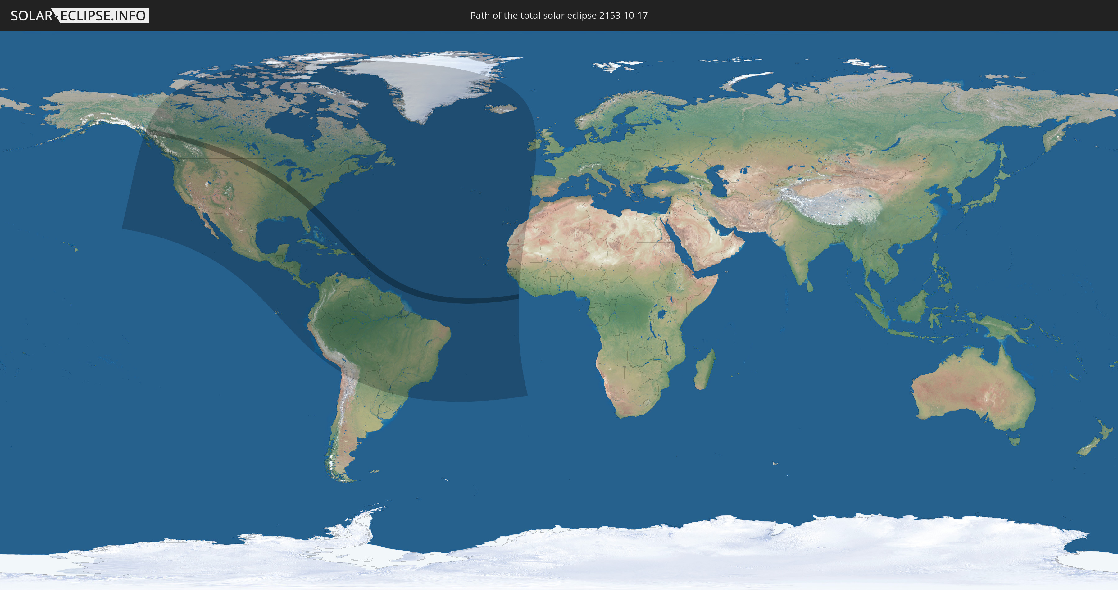
Die Sonnenfinsternis am 10/17/2153 kann man in 65 Ländern als partielle Sonnenfinsternis beobachten.
Der Finsternispfad verläuft durch 15 Länder. Nur in diesen Ländern ist sie als total Sonnenfinsternis zu sehen.
In den folgenden Ländern ist die Sonnenfinsternis total zu sehen
 United States
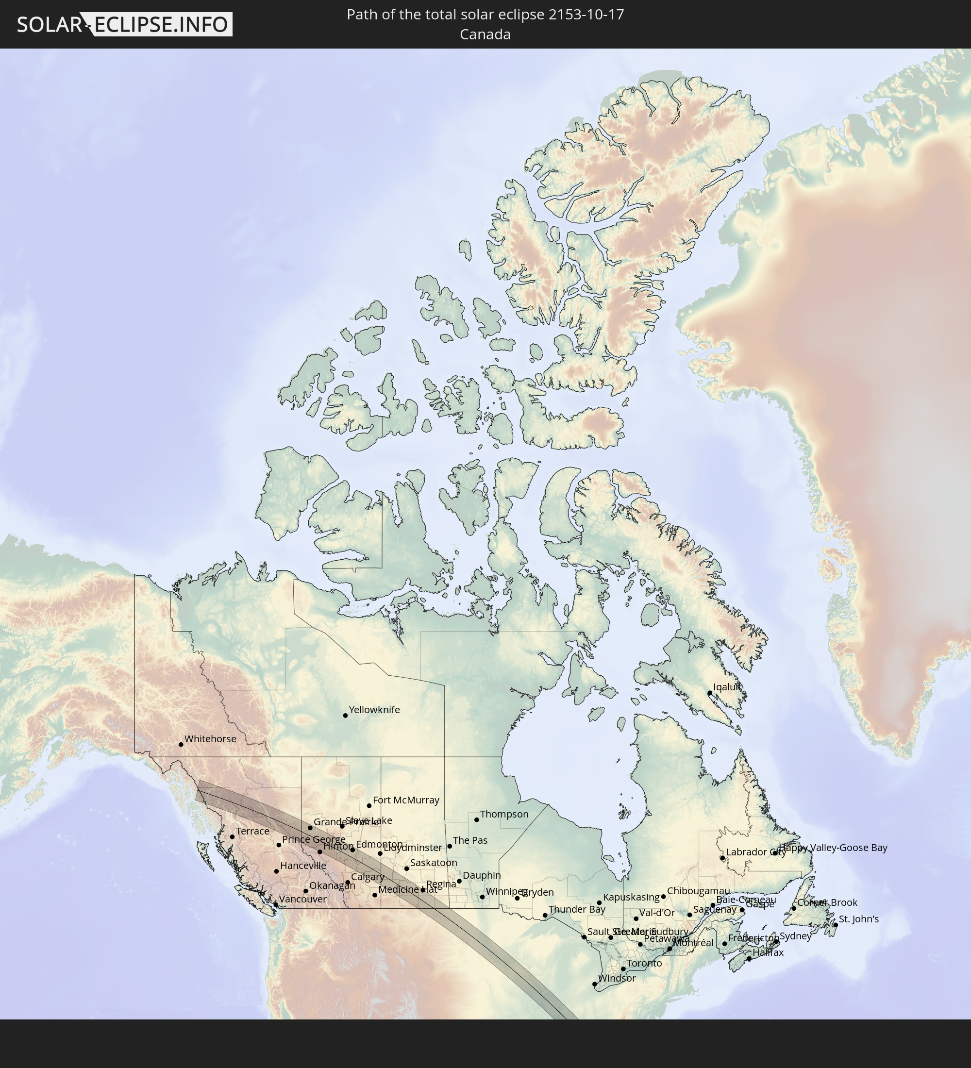 Canada
 Puerto Rico
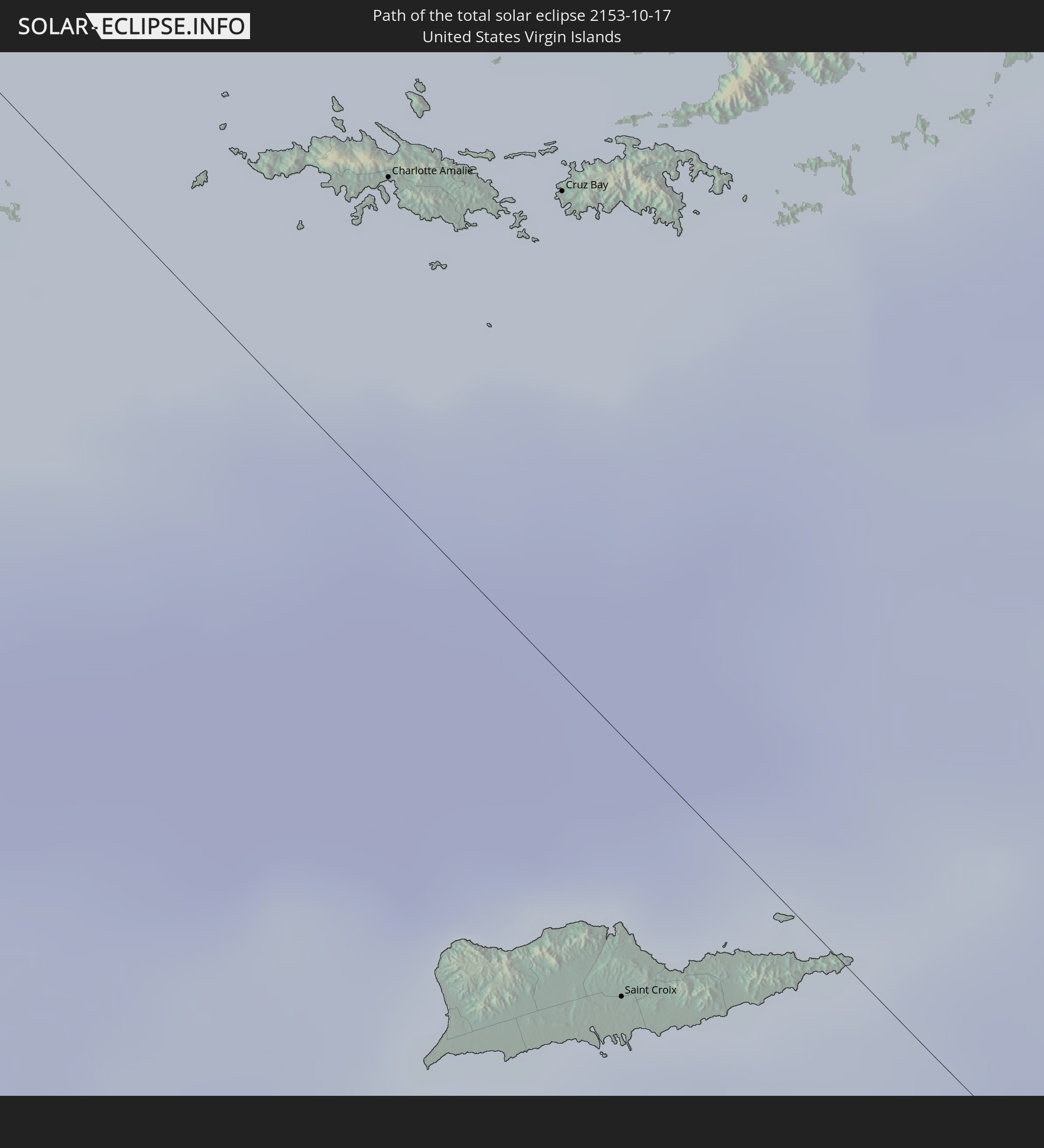 United States Virgin Islands
 British Virgin Islands
 Saint Kitts and Nevis
 Antigua and Barbuda
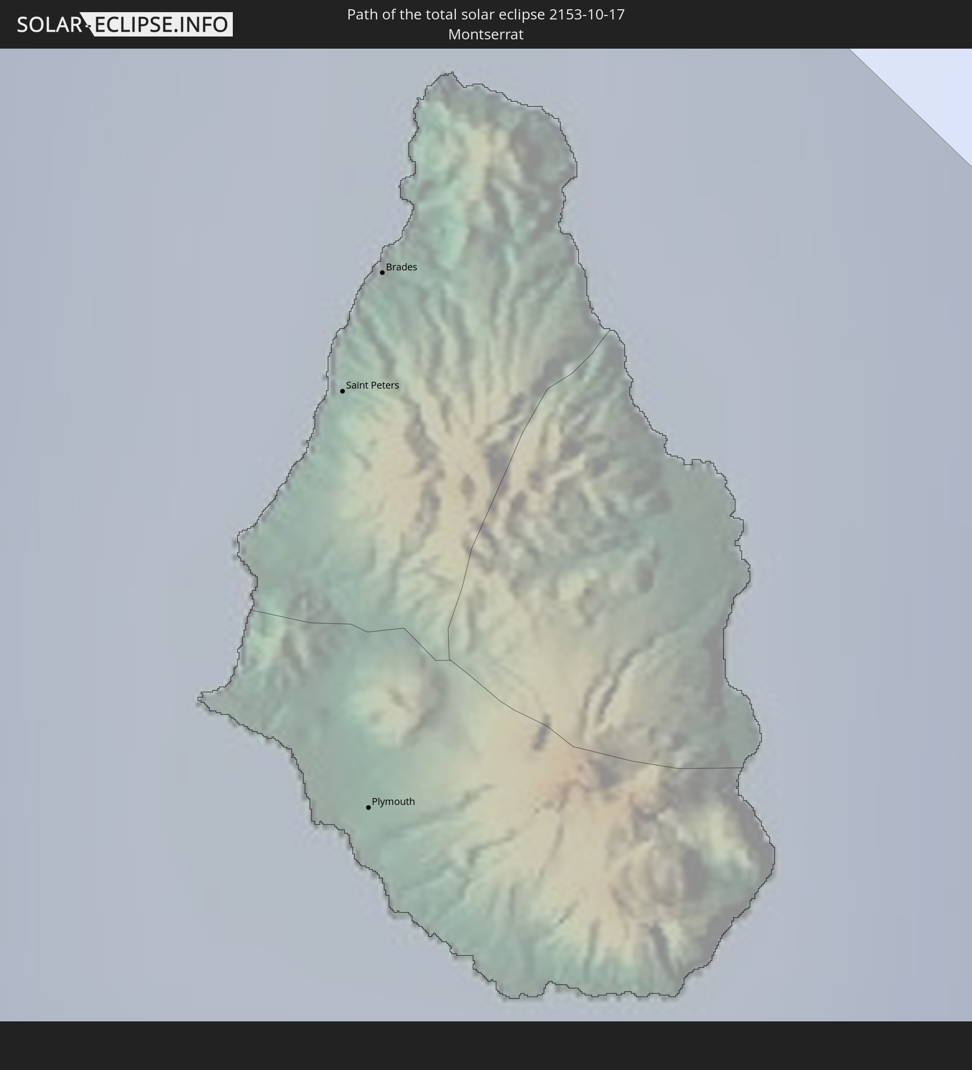 Montserrat
 Guadeloupe
 Dominica
 Saint Vincent and the Grenadines
 Martinique
 Saint Lucia
 Barbados
 Caribbean Netherlands
In den folgenden Ländern ist die Sonnenfinsternis partiell zu sehen
 United States
 United States Minor Outlying Islands
 Canada
 Mexico
 Chile
Chile
 Greenland
 Guatemala
 Ecuador
 El Salvador
 Honduras
 Belize
 Nicaragua
 Costa Rica
 Cuba
Cuba
 Panama
 Colombia
 Cayman Islands
 Peru
Peru
 The Bahamas
 Jamaica
 Haiti
Haiti
 Brazil
 Argentina
 Venezuela
 Turks and Caicos Islands
 Dominican Republic
 Aruba
Aruba
 Bolivia
 Puerto Rico
 United States Virgin Islands
 Bermuda
 British Virgin Islands
 Anguilla
 Collectivity of Saint Martin
 Saint Barthélemy
 Saint Kitts and Nevis
 Paraguay
 Antigua and Barbuda
 Montserrat
 Trinidad and Tobago
 Guadeloupe
 Grenada
 Dominica
 Saint Vincent and the Grenadines
 Guyana
 Martinique
 Saint Lucia
 Barbados
 Suriname
 Saint Pierre and Miquelon
 French Guiana
 Portugal
 Cabo Verde
 Iceland
 Spain
Spain
 Senegal
 Mauritania
 The Gambia
 Guinea-Bissau
 Guinea
 Saint Helena, Ascension and Tristan da Cunha
 Sierra Leone
 Morocco
 Republic of Ireland
 United Kingdom
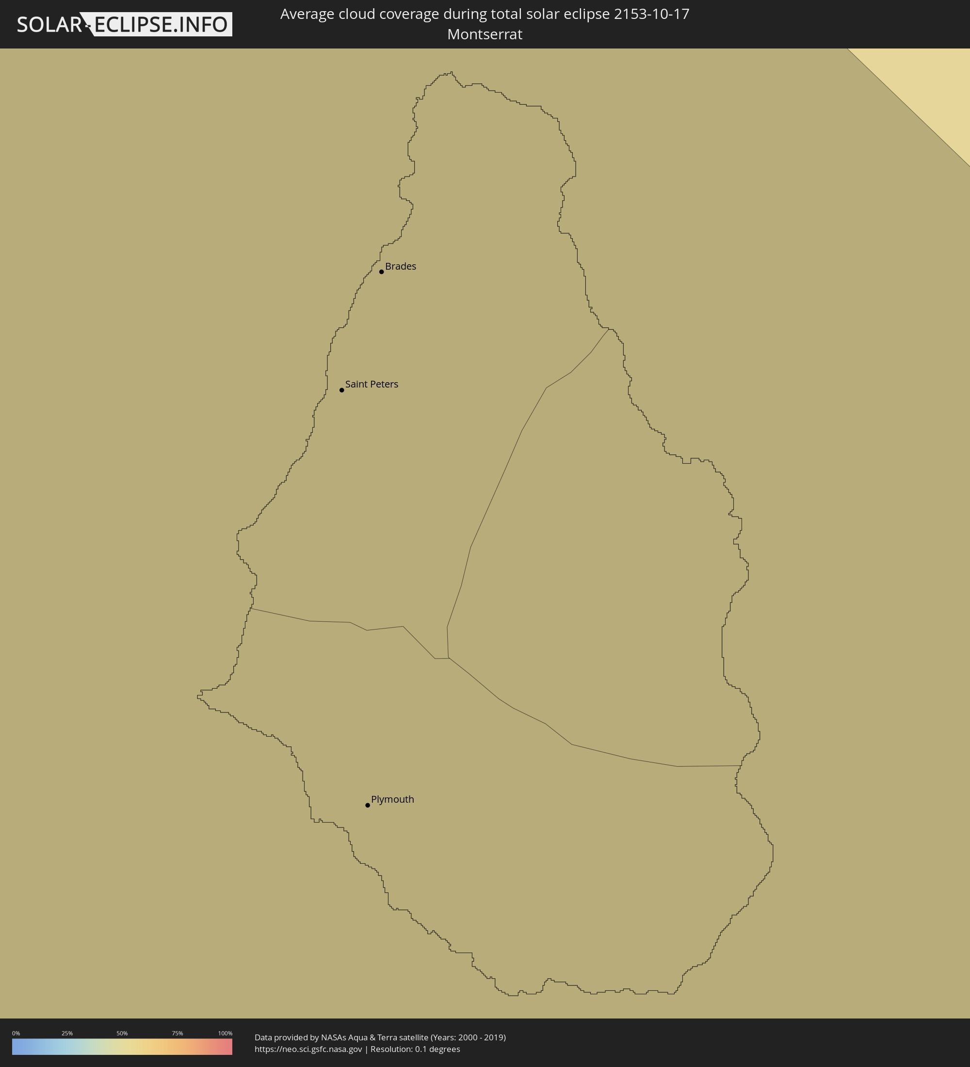
How will be the weather during the total solar eclipse on 10/17/2153?
Where is the best place to see the total solar eclipse of 10/17/2153?
The following maps show the average cloud coverage for the day of the total solar eclipse.
With the help of these maps, it is possible to find the place along the eclipse path, which has the best
chance of a cloudless sky.
Nevertheless, you should consider local circumstances and inform about the weather of your chosen
observation site.
The data is provided by NASAs satellites
AQUA and TERRA.
The cloud maps are averaged over a period of 19 years (2000 - 2019).


Detailed country maps
 United States
 Canada
 Puerto Rico
 United States Virgin Islands
 British Virgin Islands
 Saint Kitts and Nevis
 Antigua and Barbuda
 Montserrat
 Guadeloupe
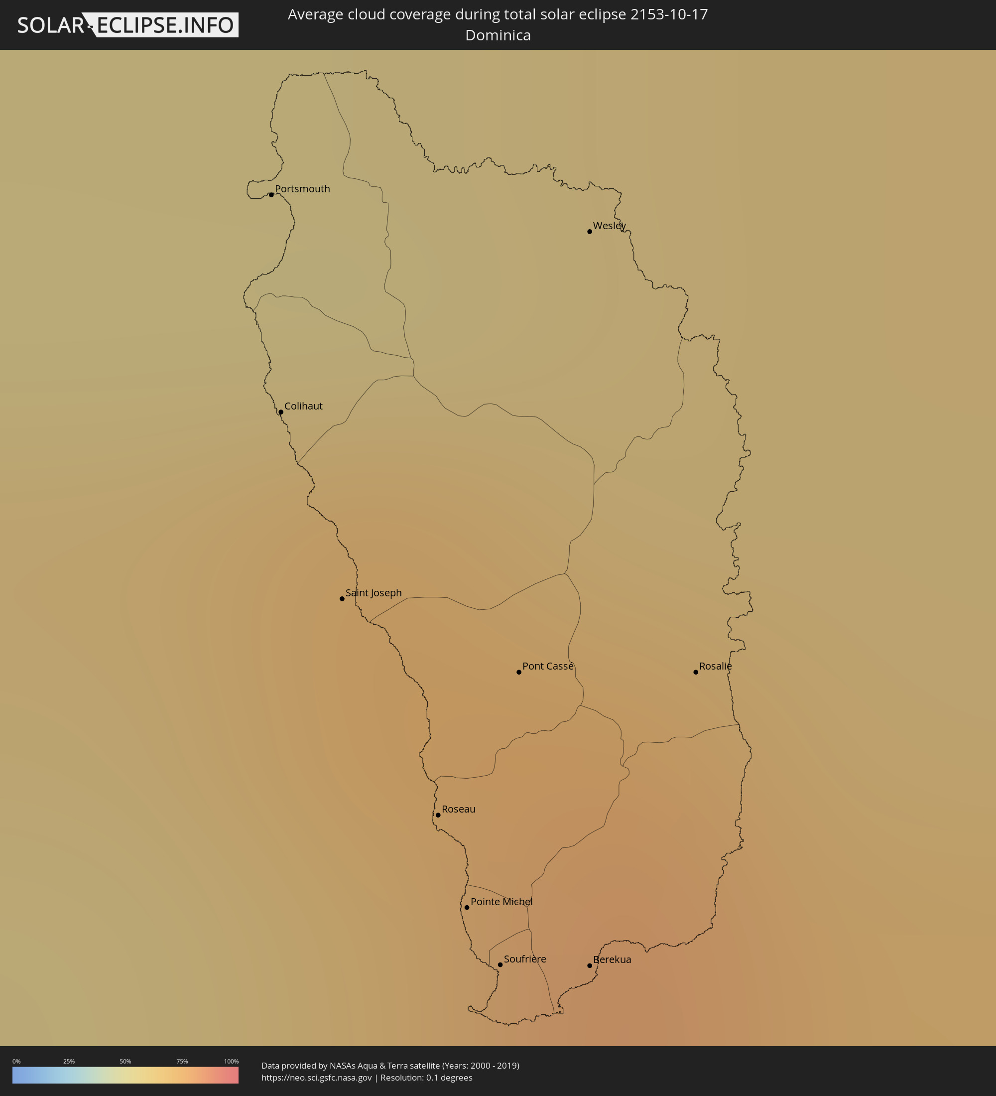 Dominica
 Saint Vincent and the Grenadines
 Martinique
 Saint Lucia
 Barbados
 Caribbean Netherlands
Cities inside the path of the eclipse
The following table shows all locations with a population of more than 5,000 inside the eclipse path. Cities which have more than 100,000 inhabitants are marked bold. A click at the locations opens a detailed map.
| City | Type | Eclipse duration | Local time of max. eclipse | Distance to central line | Ø Cloud coverage |
|
Dawson Creek, British Columbia
|
total | - | 08:40:54 UTC-07:00 | 75 km | 79% |
|
Grande Prairie, Alberta
|
total | - | 08:41:02 UTC-07:00 | 55 km | 77% |
|
Spruce Grove, Alberta
|
total | - | 08:42:13 UTC-07:00 | 39 km | 77% |
|
Red Deer, Alberta
|
total | - | 08:41:38 UTC-07:00 | 80 km | 75% |
|
Lacombe, Alberta
|
total | - | 08:41:45 UTC-07:00 | 59 km | 78% |
|
Leduc, Alberta
|
total | - | 08:42:15 UTC-07:00 | 25 km | 79% |
|
Edmonton, Alberta
|
total | - | 08:42:27 UTC-07:00 | 55 km | 76% |
|
Wetaskiwin, Alberta
|
total | - | 08:42:12 UTC-07:00 | 2 km | 78% |
|
Fort Saskatchewan, Alberta
|
total | - | 08:42:39 UTC-07:00 | 80 km | 78% |
|
Camrose, Alberta
|
total | - | 08:42:29 UTC-07:00 | 24 km | 78% |
|
Swift Current, Saskatchewan
|
total | - | 09:44:17 UTC-06:00 | 59 km | 65% |
|
Moose Jaw, Saskatchewan
|
total | - | 09:45:49 UTC-06:00 | 39 km | 72% |
|
Regina, Saskatchewan
|
total | - | 09:46:28 UTC-06:00 | 80 km | 72% |
|
Weyburn, Saskatchewan
|
total | - | 09:46:49 UTC-06:00 | 39 km | 62% |
|
Estevan, Saskatchewan
|
total | - | 09:47:21 UTC-06:00 | 26 km | 62% |
|
Rochester, Minnesota
|
total | - | 09:56:56 UTC-06:00 | 77 km | 67% |
|
Cedar Rapids, Iowa
|
total | - | 09:58:26 UTC-06:00 | 47 km | 66% |
|
Davenport, Iowa
|
total | - | 09:59:49 UTC-06:00 | 27 km | 60% |
|
Peoria, Illinois
|
total | - | 10:01:20 UTC-06:00 | 39 km | 61% |
|
Bloomington, Illinois
|
total | - | 10:02:09 UTC-06:00 | 22 km | 67% |
|
Champaign, Illinois
|
total | - | 10:03:14 UTC-06:00 | 8 km | 65% |
|
Bloomington, Indiana
|
total | - | 11:05:55 UTC-05:00 | 19 km | 60% |
|
Indianapolis, Indiana
|
total | - | 11:06:01 UTC-05:00 | 89 km | 69% |
|
Louisville, Kentucky
|
total | - | 11:07:30 UTC-05:00 | 6 km | 58% |
|
Lexington-Fayette, Kentucky
|
total | - | 11:09:22 UTC-05:00 | 59 km | 57% |
|
Knoxville, Tennessee
|
total | - | 11:11:43 UTC-05:00 | 69 km | 48% |
|
Asheville, North Carolina
|
total | - | 11:13:57 UTC-05:00 | 7 km | 44% |
|
Columbia, South Carolina
|
total | - | 11:17:40 UTC-05:00 | 27 km | 40% |
|
Charlotte, North Carolina
|
total | - | 11:16:46 UTC-05:00 | 78 km | 46% |
|
Charleston, South Carolina
|
total | - | 11:20:36 UTC-05:00 | 43 km | 45% |
|
Barceloneta, Barceloneta
|
total | - | 13:05:44 UTC-04:00 | 96 km | 59% |
|
Vega Baja, Vega Baja
|
total | - | 13:06:02 UTC-04:00 | 85 km | 70% |
|
Toa Alta, Toa Alta
|
total | - | 13:06:25 UTC-04:00 | 78 km | 78% |
|
Comerío, Comerio
|
total | - | 13:06:46 UTC-04:00 | 90 km | 79% |
|
Pájaros, Toa Alta
|
total | - | 13:06:31 UTC-04:00 | 78 km | 78% |
|
Cayey, Cayey
|
total | - | 13:07:05 UTC-04:00 | 93 km | 76% |
|
Guayama, Guayama
|
total | - | 13:07:25 UTC-04:00 | 99 km | 62% |
|
San Juan, San Juan
|
total | - | 13:06:33 UTC-04:00 | 62 km | 64% |
|
Aguas Buenas, Aguas Buenas
|
total | - | 13:06:56 UTC-04:00 | 77 km | 79% |
|
Caguas, Caguas
|
total | - | 13:07:05 UTC-04:00 | 75 km | 77% |
|
Carolina, Carolina
|
total | - | 13:06:59 UTC-04:00 | 57 km | 75% |
|
Humacao, Humacao
|
total | - | 13:07:40 UTC-04:00 | 65 km | 59% |
|
Naguabo, Naguabo
|
total | - | 13:07:44 UTC-04:00 | 53 km | 59% |
|
Fajardo, Fajardo
|
total | - | 13:07:41 UTC-04:00 | 38 km | 66% |
|
Isabel Segunda, Vieques Municipality
|
total | - | 13:08:25 UTC-04:00 | 35 km | 54% |
|
Charlotte Amalie, Saint Thomas Island
|
total | - | 13:09:04 UTC-04:00 | 19 km | 57% |
|
Cruz Bay, Saint John Island
|
total | - | 13:09:21 UTC-04:00 | 28 km | 58% |
|
Saint Croix, Saint Croix Island
|
total | - | 13:10:33 UTC-04:00 | 15 km | 59% |
|
Road Town
|
total | - | 13:09:31 UTC-04:00 | 49 km | 65% |
 The Bottom, Saba
|
total | - | 13:13:40 UTC-04:00 | 90 km | 51% |
|
Oranjestad, Sint Eustatius
|
total | - | 13:14:28 UTC-04:00 | 99 km | 55% |
|
Sandy Point Town, Saint Anne Sandy Point
|
total | - | 13:14:57 UTC-04:00 | 99 km | 63% |
|
Saint Paul’s, Saint Paul Capesterre
|
total | - | 13:14:56 UTC-04:00 | 105 km | 63% |
|
Middle Island, Saint Thomas Middle Island
|
total | - | 13:15:06 UTC-04:00 | 98 km | 59% |
|
Dieppe Bay Town, Saint John Capesterre
|
total | - | 13:14:55 UTC-04:00 | 106 km | 63% |
|
Trinity, Trinity Palmetto Point
|
total | - | 13:15:13 UTC-04:00 | 100 km | 59% |
|
Nicola Town, Christ Church Nichola Town
|
total | - | 13:15:08 UTC-04:00 | 107 km | 63% |
|
Cayon, Saint Mary Cayon
|
total | - | 13:15:12 UTC-04:00 | 107 km | 57% |
|
Basseterre, Saint George Basseterre
|
total | - | 13:15:19 UTC-04:00 | 103 km | 57% |
|
Monkey Hill, Saint Peter Basseterre
|
total | - | 13:15:17 UTC-04:00 | 105 km | 57% |
|
Charlestown, Saint Paul Charlestown
|
total | - | 13:15:49 UTC-04:00 | 98 km | 54% |
|
Cotton Ground, Saint Thomas Lowland
|
total | - | 13:15:46 UTC-04:00 | 101 km | 60% |
|
Fig Tree, Saint John Figtree
|
total | - | 13:15:53 UTC-04:00 | 98 km | 54% |
|
Newcastle, Saint James Windwa
|
total | - | 13:15:46 UTC-04:00 | 106 km | 60% |
|
Market Shop, Saint George Gingerland
|
total | - | 13:15:57 UTC-04:00 | 101 km | 54% |
|
Saint Peters, Saint Peter
|
total | - | 13:17:17 UTC-04:00 | 99 km | 65% |
|
Plymouth, Saint Anthony
|
total | - | 13:17:25 UTC-04:00 | 94 km | 59% |
|
Brades, Saint Peter
|
total | - | 13:17:15 UTC-04:00 | 101 km | 65% |
|
Pointe-Noire, Guadeloupe
|
total | - | 13:19:08 UTC-04:00 | 87 km | 67% |
|
Bouillante, Guadeloupe
|
total | - | 13:19:21 UTC-04:00 | 80 km | 60% |
|
Vieux-Habitants, Guadeloupe
|
total | - | 13:19:29 UTC-04:00 | 75 km | 60% |
|
Baillif, Guadeloupe
|
total | - | 13:19:36 UTC-04:00 | 73 km | 63% |
|
Basse-Terre, Guadeloupe
|
total | - | 13:19:41 UTC-04:00 | 73 km | 63% |
|
Saint-Claude, Guadeloupe
|
total | - | 13:19:41 UTC-04:00 | 77 km | 63% |
|
Sainte-Rose, Guadeloupe
|
total | - | 13:19:07 UTC-04:00 | 102 km | 77% |
|
Gourbeyre, Guadeloupe
|
total | - | 13:19:46 UTC-04:00 | 75 km | 63% |
|
Trois-Rivières, Guadeloupe
|
total | - | 13:19:53 UTC-04:00 | 77 km | 63% |
|
Lamentin, Guadeloupe
|
total | - | 13:19:22 UTC-04:00 | 102 km | 72% |
|
Petit-Bourg, Guadeloupe
|
total | - | 13:19:35 UTC-04:00 | 98 km | 65% |
|
Baie-Mahault, Guadeloupe
|
total | - | 13:19:28 UTC-04:00 | 105 km | 72% |
|
Capesterre-Belle-Eau, Guadeloupe
|
total | - | 13:19:55 UTC-04:00 | 88 km | 63% |
|
Pointe-à-Pitre, Guadeloupe
|
total | - | 13:19:36 UTC-04:00 | 106 km | 60% |
|
Portsmouth, Saint John
|
total | - | 13:20:58 UTC-04:00 | 58 km | 63% |
|
Colihaut, Saint Peter
|
total | - | 13:21:09 UTC-04:00 | 50 km | 62% |
|
Saint Joseph, Saint Joseph
|
total | - | 13:21:22 UTC-04:00 | 45 km | 67% |
|
Roseau, Saint George
|
total | - | 13:21:39 UTC-04:00 | 41 km | 61% |
|
Pointe Michel, Saint Luke
|
total | - | 13:21:45 UTC-04:00 | 38 km | 61% |
|
Soufrière, Saint Mark
|
total | - | 13:21:50 UTC-04:00 | 37 km | 56% |
|
Pont Cassé, Saint Paul
|
total | - | 13:21:36 UTC-04:00 | 49 km | 67% |
|
Berekua, Saint Patrick
|
total | - | 13:21:55 UTC-04:00 | 40 km | 62% |
|
Wesley, Saint Andrew
|
total | - | 13:21:17 UTC-04:00 | 68 km | 63% |
|
Grand-Bourg, Guadeloupe
|
total | - | 13:20:42 UTC-04:00 | 94 km | 62% |
|
Rosalie, Saint David
|
total | - | 13:21:46 UTC-04:00 | 55 km | 79% |
|
Georgetown, Charlotte
|
total | - | 13:25:54 UTC-04:00 | 109 km | 70% |
|
Fort-de-France, Martinique
|
total | - | 13:23:33 UTC-04:00 | 6 km | 69% |
|
Le Lorrain, Martinique
|
total | - | 13:23:10 UTC-04:00 | 26 km | 81% |
|
Soufrière, Soufrière
|
total | - | 13:24:59 UTC-04:00 | 56 km | 66% |
|
Choiseul, Choiseul Quarter
|
total | - | 13:25:10 UTC-04:00 | 62 km | 65% |
|
Saint-Joseph, Martinique
|
total | - | 13:23:30 UTC-04:00 | 14 km | 75% |
|
Anse La Raye, Anse-la-Raye
|
total | - | 13:24:51 UTC-04:00 | 47 km | 75% |
|
Les Trois-Îlets, Martinique
|
total | - | 13:23:45 UTC-04:00 | 3 km | 63% |
|
Castries, Castries Quarter
|
total | - | 13:24:50 UTC-04:00 | 40 km | 69% |
|
Le Gros-Morne, Martinique
|
total | - | 13:23:32 UTC-04:00 | 19 km | 75% |
|
Sainte-Marie, Martinique
|
total | - | 13:23:23 UTC-04:00 | 26 km | 70% |
|
Laborie, Laborie Quarter
|
total | - | 13:25:20 UTC-04:00 | 59 km | 65% |
|
Ducos, Martinique
|
total | - | 13:23:49 UTC-04:00 | 10 km | 71% |
|
Bisée, Castries Quarter
|
total | - | 13:24:50 UTC-04:00 | 36 km | 69% |
|
La Trinité, Martinique
|
total | - | 13:23:32 UTC-04:00 | 25 km | 75% |
|
Gros Islet, Gros-Islet
|
total | - | 13:24:48 UTC-04:00 | 30 km | 62% |
|
Vieux Fort, Vieux-Fort
|
total | - | 13:25:27 UTC-04:00 | 60 km | 59% |
|
Le Robert, Martinique
|
total | - | 13:23:41 UTC-04:00 | 21 km | 60% |
|
Saint-Esprit, Martinique
|
total | - | 13:23:56 UTC-04:00 | 11 km | 70% |
|
Sainte-Luce, Martinique
|
total | - | 13:24:06 UTC-04:00 | 5 km | 66% |
|
Rivière-Pilote, Martinique
|
total | - | 13:24:08 UTC-04:00 | 7 km | 66% |
|
Le François, Martinique
|
total | - | 13:23:52 UTC-04:00 | 19 km | 70% |
|
Micoud, Micoud Quarter
|
total | - | 13:25:22 UTC-04:00 | 48 km | 65% |
|
Praslin, Praslin
|
total | - | 13:25:17 UTC-04:00 | 44 km | 69% |
|
Dennery, Dennery Quarter
|
total | - | 13:25:14 UTC-04:00 | 40 km | 69% |
|
Le Marin, Martinique
|
total | - | 13:24:12 UTC-04:00 | 9 km | 66% |
|
Le Vauclin, Martinique
|
total | - | 13:24:08 UTC-04:00 | 18 km | 60% |
|
Speightstown, Saint Peter
|
total | - | 13:28:52 UTC-04:00 | 8 km | 71% |
|
Holetown, Saint James
|
total | - | 13:29:01 UTC-04:00 | 13 km | 76% |
|
Checker Hall, Saint Lucy
|
total | - | 13:28:51 UTC-04:00 | 4 km | 67% |
|
Bridgetown, Saint Michael
|
total | - | 13:29:13 UTC-04:00 | 19 km | 68% |
|
Greenland, Saint Andrew
|
total | - | 13:29:02 UTC-04:00 | 2 km | 67% |
|
Welchman Hall, Saint Thomas
|
total | - | 13:29:10 UTC-04:00 | 8 km | 76% |
|
Oistins, Christ Church
|
total | - | 13:29:26 UTC-04:00 | 16 km | 66% |
|
Bathsheba, Saint Joseph
|
total | - | 13:29:11 UTC-04:00 | 3 km | 71% |
|
Four Cross Roads, Saint John
|
total | - | 13:29:17 UTC-04:00 | 6 km | 71% |
|
Crane, Saint Philip
|
total | - | 13:29:32 UTC-04:00 | 7 km | 66% |